Mind the Gap – Hike Mt. Tammany and Mt. Minsi in One Day. Double Your Summits, Double Your Fun!
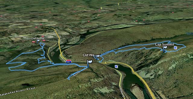
Climb Mt. Tammany (NJ) and Mt. Minsi (PA) on either side of the Delaware Water Gap… in the same day. More views than you can shake a hiking stick at. Yowza!
Hike Info:
Our two cents:
This challenge combines two classic hikes in the Delaware Water Gap, and lets you see the Gap from both summits in one day.
Outstanding views on each trail. At Minsi’s summit, see where you’ve been on Mt. Tammany’s summit and vice versa… rather nifty.
Miles:
8.6 or 12.2 miles total; challenging. It’s not the distance on these hikes – it’s the steepness. Mt Tammany will especially get the old ticker pumping (you are in good shape, right?).
In planning your hike:
Factor in driving time.
If you are driving from central Jersey, Mt. Tammany’s parking is about 1.5-1.75 hrs away. Mt. Minsi’s trailhead is about 10-15 minutes away.
So, if you were coming from even further it might be more driving than you want to do in one day. Consider an overnight stay, you deserve it.
Optionally, walk instead of drive: 12.2 miles.
Connect the hikes with a roughly 1.8-mile road walk over the bridge following the WHITE blazes of the Appalachian Trail (so this adds about 3.6 miles total to your hike).
On busy weekends, this could be faster than driving and parking to the other hike – parking areas on both of these fill up early on weekends.
We have not done this (we generally avoid road walking), but you can see the walking route between hikes.
Decide on a start side.
Coming from New Jersey, the Mt. Tammany lot is closer. There is a small toll to drive from NJ into PA. On the PA side, there are closer post-hike food options in town than on the New Jersey side.
Related: Challenging Hikes in NJ
Directions:
Simply use our hike pages for each section, Mt. Tammany and Mt. Minsi.
Also check out our blog post, “Mind the Gap” – Mt Tammany and Mt Minsi in One Day.

My buddy and I will be doing this hike sometime this month, very excited! Thanks for having all of this info put together!
My boyfriend and I are going this weekend, is there a fee? Can we take our dogs?
Hello Samantha – there are no fees, and dogs on a 6-foot leash are allowed on the trail. For more info and some park areas that pets aren’t allowed, check the Delaware Water Gap NRA site at nps.gov/dewa/
They have T shirts etc. why do they not have a patch?
I’m planning to go this Saturday, July 1st , 2017 to mt Tammany with a friend, cousin and daughter (14 years old).. I read that people have encountered snakes and bears, what are the chances, should I really be concern and how to prepare ourselves in case of a snake??
Hello Ivellis – There is always a chance of a wildlife encounter, however Mt Tammany is one of the most trafficked hikes in the state so that cuts down the chances a lot, and it’s not something to be overly concerned with. Bears and snakes generally avoid people if they can. We have some tips about both here: https://www.njhiking.com/hiking-101/#wildlife
What is it called if hike all of it, instead of driving between the mountains?
Mike – The same thing I suppose. When we coined the name for it many years ago we never really thought about making a distinction.
Looks like a great outing. Is there camping anywhere along the trail?
Chuck – not on either of these trails, but there are campgrounds
nearby, like in Worthington SF.
I was looking for some help. Can you help me with a mile total for today? I am disappointed my tracker app failed us. I am coming up with 11 miles, but that sounds a bit much. It did take us almost 6 hours, so who knows. We started on the red dot front he parking lot, and then at the peak we went along the Blue dot and decided to go to the Fire Road trail. We took that for what seemed FOREVER and is unmarked so I can’t find a distance. This connected with the Turquoise trail, and then we went onto the Sunfish Pond trail and finally to the Dunnfield Creek trail back to the car. Any help on calculations would be really appreciated
Hi Tori – I think you did this route or close to it, depending on how much you hiked in the Sunfish Pond area:
Mt. Tammany and Sunfish Pond – 10.7 miles
https://www.njhiking.com/nj-challenging-hikes-mt-tammany-sunfish-pond/
Click the “online map” link to see our GPS data overlaid on a Interactive Map, and you can download the GPX as well.
We also have a route/mileage chart on the main Sunfish page that might help.
https://www.njhiking.com/sunfish-pond/
This is one of our favorite routes in NJ – but yes the fire road can feel like forever sometimes. Catch it at the right time and there can be tons of blueberries along it however.
Hope that helps some,
Dawn
Hi,
Been to both peaks a few times, but in the fall.
Not very sure-footed in the winter, with packed snow or ice.
Is there any way I can check local ground conditions?
Thank you
Hi Swetha – Try contacting the parks directly for current conditions. Also, check their Facebook page to see if they’ve posted anything.
And if you use Instagram, you can trying checking for recent photos that have been uploaded using tags like #MtTammany #MtMinsi or #delawarewatergap.
Hope that helps,
Dawn
Minded the gap today (driving between) in 4 hr and 15 minutes. Challenging but fun